
File:Latitude and longitude graticule on an ellipsoid.svg

此SVG文件的PNG预览的大小:660 × 600像素。 其他分辨率:264 × 240像素 | 528 × 480像素 | 845 × 768像素 | 1,126 × 1,024像素 | 2,253 × 2,048像素 | 825 × 750像素。
原始文件 (SVG文件,尺寸为825 × 750像素,文件大小:102 KB)
摘要
| 描述 |
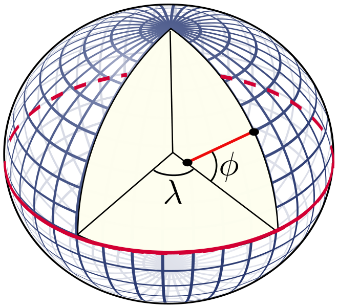
English: The definition of latitude (φ) and longitude (λ) on an ellipsoid of revolution (or spheroid). The graticule spacing is 10 degrees. The latitude is defined as the angle between the normal to the ellipsoid and the equatorial plane. |
| 日期 | |
| 来源 | 自己的作品 |
| 作者 | Peter Mercator |
| 其他版本 |
The graticule was taken from the file Sphere wireframe 10deg 10r.svg. 本檔案衍生自: Sphere wireframe 10deg 10r.svg |
| SVG开发 |
许可协议
| 我,本作品著作权人,释出本作品至公有领域。这适用于全世界。 在一些国家这可能不合法;如果是这样的话,那么: 我无条件地授予任何人以任何目的使用本作品的权利,除非这些条件是法律规定所必需的。 |
文件历史
点击某个日期/时间查看对应时刻的文件。
| 日期/时间 | 缩略图 | 大小 | 用户 | 备注 | |
|---|---|---|---|---|---|
| 当前 | 2010年12月5日 (日) 21:20 | | 825 × 750(102 KB) | Peter Mercator | {{Information |Description={{en|1=The definition of latitude and longitude on an ellipsoid of revolution (or spheroid). The graticule spacing is 10 degrees. The latitude is defined as the angle between the normal to the ellipsoid and the equatorial plane. |
文件用途
全域文件用途
以下其他wiki使用此文件:
- bg.wikipedia.org上的用途
- ca.wikipedia.org上的用途
- cs.wikipedia.org上的用途
- de.wikipedia.org上的用途
- en.wikipedia.org上的用途
- Cartography
- Geodesy
- Latitude
- Navigation
- Geophysics
- Earth radius
- Geoid
- Very-long-baseline interferometry
- Remote sensing
- Spherical Earth
- World Geodetic System
- History of geodesy
- Figure of the Earth
- Geomatics
- Photogrammetry
- Earth's orbit
- Geodetic datum
- Geodetic astronomy
- Virtual globe
- Category:Geodesists
- Gravity of Earth
- Earth ellipsoid
- Computer cartography
- Inertial navigation system
- User:Peter Mercator/Draft figures
- Template:Portal/doc/all
- Portal:Geophysics
- Earth's circumference
- Geopositioning
- List of geodesists
- Empirical evidence for the spherical shape of Earth
- Template:Geodesy navbox
- Portal:Geodesy
- User:Certes/Reports/Portals
- Timeline of Earth estimates
- ja.wikipedia.org上的用途
- ja.wikibooks.org上的用途
- ko.wikipedia.org上的用途
- nl.wikipedia.org上的用途
- pt.wikipedia.org上的用途
- sl.wikipedia.org上的用途
- ta.wikipedia.org上的用途
- tum.wikipedia.org上的用途