
Rothenfels
Rothenfels | |
|---|---|
 Rothenfels from the northeast across the Main, Rothenfels Castle in the background | |
 Coat of arms | |
Location of Rothenfels within Main-Spessart district  | |
 Rothenfels  Rothenfels | |
| Coordinates: 49°53′N 9°35′E / 49.883°N 9.583°E | |
| Country | Germany |
| State | Bavaria |
| Admin. region | Unterfranken |
| District | Main-Spessart |
| Municipal assoc. | Marktheidenfeld |
| Government | |
| • Mayor (2020–26) | Michael Gram[1] |
| Area | |
| • Total | 12.07 km2 (4.66 sq mi) |
| Elevation | 154 m (505 ft) |
| Population (2024-12-31)[2] | |
| • Total | 947 |
| • Density | 78/km2 (200/sq mi) |
| Time zone | UTC+01:00 (CET) |
| • Summer (DST) | UTC+02:00 (CEST) |
| Postal codes | 97851 |
| Dialling codes | 09393 |
| Vehicle registration | MSP |
| Website | www.rothenfels.de |
Rothenfels is a town in the Main-Spessart district in the Regierungsbezirk of Lower Franconia (Unterfranken) in Bavaria, Germany and a member of the Verwaltungsgemeinschaft (municipal association) of Marktheidenfeld. With a population of just around 1,000 it is said to be Bavaria’s smallest town.
Geography
[change | change source]Location
[change | change source]Rothenfels is on the Main’s right edge between Lohr and Marktheidenfeld, 5 km north of Marktheidenfeld, and 33 km east of Aschaffenburg. Squeezed as it is between the river and a bluff, the town consists of little more than a main street. Since 2006, the Maindamm, previously part of the railway line Lohr-Wertheim has been used as a town bypass.
Neighbouring communities
[change | change source]From the north, clockwise: Neustadt am Main, Marktheidenfeld, Hafenlohr, Fürstlich Löwensteinscher Park (gemeindefreies Gebiet).
Subdivisions
[change | change source]Rothenfels has two Stadtteile, Rothenfels in the valley of the Main and Bergrothenfels on the hill, next to Rothenfels Castle (Burg Rothenfels).
Gallery
[change | change source] Main street
 Church
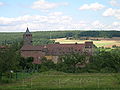 Rothenfels Castle


References
[change | change source]- ↑ Liste der ersten Bürgermeister/Oberbürgermeister in kreisangehörigen Gemeinden, Bayerisches Landesamt für Statistik, 15 July 2021.
- ↑ "Gemeinden, Kreise und Regierungsbezirke in Bayern, Einwohnerzahlen am 31. Dezember 2024; Basis Zensus 2022" [Municipalities, counties, and administrative districts in Bavaria; Based on the 2022 Census] (CSV) (in German). Bayerisches Landesamt für Statistik.
Other websites
[change | change source]- Town’s official webpage Archived 2016-07-09 at the Wayback Machine (in German)
- Rothenfels Castle (in German)

| International | |
|---|---|
| National | |
| Other | |